| 《桌面地圖制圖系統》(Pitney Bowes MapInfo Professional)v11.5.0.16[壓縮包] | |
|---|---|
| 下載分級 | 软件资源 |
| 資源類別 | 行業軟件 |
| 發布時間 | 2017/7/11 |
| 大 小 | - |
《桌面地圖制圖系統》(Pitney Bowes MapInfo Professional)v11.5.0.16[壓縮包] 簡介: 中文名 : 桌面地圖制圖系統 英文名 : Pitney Bowes MapInfo Professional 資源格式 : 壓縮包 版本 : v11.5.0.16 發行時間 : 2012年 制作發行 : Pitney Bowes Software Inc. 語言 : 英文 簡介 : MapInfo Professional是由MapInfo公司出品的一款桌面地圖制圖
電驢資源下載/磁力鏈接資源下載:
全選
"《桌面地圖制圖系統》(Pitney Bowes MapInfo Professional)v11.5.0.16[壓縮包]"介紹
中文名: 桌面地圖制圖系統
英文名: Pitney Bowes MapInfo Professional
資源格式: 壓縮包
版本: v11.5.0.16
發行時間: 2012年
制作發行: Pitney Bowes Software Inc.
語言: 英文
簡介:

MapInfo Professional是由MapInfo公司出品的一款桌面地圖制圖系統。MapInfo Professional可以在一張地圖上合並和顯示不同格式和投影的地圖數據。
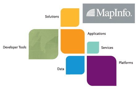
MapInfo Professional 是一款功能強大、用戶界面友好的商業繪圖及分析工具,包含令人耳目一新的用戶界面、訪問開源數據庫PostGIS的權限以及內置的對於 Layered PDF生成的支持。這款極具成本效益的解決方案,將幫助企業在庫存管理、資源配置、客戶溝通的決策制定的過程中從數據中獲得最大的價值。
MapInfo Professional 優勢包括:
• 更加出色的易用性——提供了一個更加直觀的用戶界面,通過Layered PDF實現數據共享,使企業能夠更加方便、高效地創建和分享自定義地圖,有利於提高效率、節省時間。
• 大量的成本節省——MapInfo Professional 支持開源數據庫PostGIS,為用戶提供了具有成本效益以及開源的選擇。
• 增強的數據存取——企業可以利用包括Microsoft SQL Server® 2008在內更多的數據,獲得更加充分的靈活性,並可持續訪問多種類型的數據。
“對我們而言,MapInfo Professional 的推出是一個重要的裡程碑。PBBI公司致力於幫助企業在制定關鍵的商業決策時能從數據中獲得最大的價值。我們征求了數以萬計客戶的意見,以確保 MapInfo Professional 能夠最大限度地滿足客戶的需求。”PBBI公司總裁Michael Hickey表示。“在當今充滿挑戰的經濟環境中,企業迫切需要利用工具制定資源配置、庫存管理、客戶協調等方面的決策。MapInfo Professional提供了一種具有成本效益、易於使用的解決方案,有利於企業制定前瞻性的商業決策,提升核心競爭力。”
Supported Operating Systems:
Windows XP Professional 32-bit Service Pack 3 (SP3)
Windows 7 Ultimate 32-bit SP1
Windows 7 Ultimate 64-bit SP1 with 32-bit compatibility mode
Windows 2008 Server 32-bit SP2
Windows 2008 Server R2 64-bit SP1 with XenServer 6.0
Windows 2008 Server R2 64-bit SP1
Supported Databases:
XY - i.e. Databases that store point data as X & Y numeric columns:
Microsoft Access 2007, 2010
Microsoft SQL Server 2005
Microsoft SQL Server 2008 XY on a spatialized DB
Oracle Spatial 10Gr2, 11Gr2
PostgreSQL 9.0 with PostGIS 1.5.2
Spatial - Databases that store map data as objects including: points lines and regions
Microsoft SQL Server 2012
SQL Server 2005 with SpatialWare 4.9
SQL Server 2008
Oracle Spatial 11Gr2, 10Gr2.
PostgreSQL 9.0 with PostGIS 1.5.2
MS Office Data Types:
MS Office 2010 - MS Excel (.XLS) & MS Access (.MDB)
MS Office 2007 - MS Excel (.XLSX) and MS Access (.MCCDB)
Supported Languages:
English
French
German
Italian
Spanish
Danish
Finnish
Japanese
Simplified Chinese
Swedish
Dutch
Czech
Hebrew
Korean
Polish
Brazilian Portuguese
Russian
Turkish

資源更新列表
http://www.VeryCD.com/i/5190747/create/fol...postTime
MapInfo Professional is a powerful WeiRuan® ShiChuang®-based mapping and geographic analysis application from the experts in location intelligence. Designed to easily visualize the relationships between data and geography, MapInfo Professional helps business analysts, planners, GIS professionals - even non-GIS users - gain new insights into their markets, share information-rich maps and graphs and improve strategic decision-making.
See your business data in powerful new ways
* Discover trends hidden in spreadsheets and charts
* Gain new understanding of your customers and markets
* Perform powerful data analysis and calculations
* Create custom maps and content for analysis
Use geographic insights to innovate business processes
* Manage location-based assets, people and property
* Optimize service and sales territories for greater efficiencies
* Deploy networks, infrastructure and utilities with confidence
* Map resources, plan logistics and prepare for emergencies
Works and plays well with existing IT infrastructure
* Designed and tested with ShiChuang operating systems
* Imports and exports data in a wide variety of formats
* Easily customized to meet your specific needs
Data access
MapInfo Professional® provides built-in support to access and view a variety of data formats directly. This means you will be able to view your WeiRuan Excel®, WeiRuan Access® or database data, such as Oracle®, WeiRuan® SQL Server as well as many other file formats, directly out of the box. You can also view images of virtually any format. This capability ensures that MapInfo Professional will fit into your current IT structure directly with no additional cost.
Data creation & editing
MapInfo Professional provides many CAD data creation and editing tools as well as the ability to edit your tabular data such as values and names. This means you don't have to switch between applications. Make all your changes for maps and data in one application and save time and effort.
Display
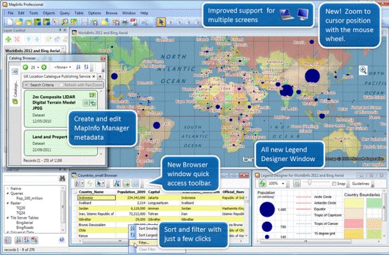
Map display options are one of the great strengths of MapInfo Professional. You can instantly shade/change style or mark territories (using any symbol, graduated symbols, charts or graphs), boundaries, highways, fiber lines or points based on any tabular data values through a simple wizard. You can also aggregate values using statistical or any math functions to associate a symbol or a color to a point or a region based on a calculated value. For example, shade the sales territories based on number of customers. Trends based on geography reveal themselves, patterns become clear and better decisions with impact are imminent.
Data & map publishing
Sharing your results in industry formats is often as critical as the information itself. In today's IT environment, the need to have multiple publishing options is critical to meaningful communication between applications. MapInfo Professional provides a spectrum of options for this purpose. From the ability to export data to any format, to publishing large maps with legends and charts, MapInfo Professional seamlessly integrates across applications. In addition, MapInfo Professional is Web-enabled. Publish static or interactive maps through easy-to-use wizards. Share the results in a format that best fits your needs.
Home Page - http://www.mapinfo.com/
代碼
英文名: Pitney Bowes MapInfo Professional
資源格式: 壓縮包
版本: v11.5.0.16
發行時間: 2012年
制作發行: Pitney Bowes Software Inc.
語言: 英文
簡介:
MapInfo Professional是由MapInfo公司出品的一款桌面地圖制圖系統。MapInfo Professional可以在一張地圖上合並和顯示不同格式和投影的地圖數據。
MapInfo Professional 是一款功能強大、用戶界面友好的商業繪圖及分析工具,包含令人耳目一新的用戶界面、訪問開源數據庫PostGIS的權限以及內置的對於 Layered PDF生成的支持。這款極具成本效益的解決方案,將幫助企業在庫存管理、資源配置、客戶溝通的決策制定的過程中從數據中獲得最大的價值。
MapInfo Professional 優勢包括:
• 更加出色的易用性——提供了一個更加直觀的用戶界面,通過Layered PDF實現數據共享,使企業能夠更加方便、高效地創建和分享自定義地圖,有利於提高效率、節省時間。
• 大量的成本節省——MapInfo Professional 支持開源數據庫PostGIS,為用戶提供了具有成本效益以及開源的選擇。
• 增強的數據存取——企業可以利用包括Microsoft SQL Server® 2008在內更多的數據,獲得更加充分的靈活性,並可持續訪問多種類型的數據。
“對我們而言,MapInfo Professional 的推出是一個重要的裡程碑。PBBI公司致力於幫助企業在制定關鍵的商業決策時能從數據中獲得最大的價值。我們征求了數以萬計客戶的意見,以確保 MapInfo Professional 能夠最大限度地滿足客戶的需求。”PBBI公司總裁Michael Hickey表示。“在當今充滿挑戰的經濟環境中,企業迫切需要利用工具制定資源配置、庫存管理、客戶協調等方面的決策。MapInfo Professional提供了一種具有成本效益、易於使用的解決方案,有利於企業制定前瞻性的商業決策,提升核心競爭力。”
Supported Operating Systems:
Windows XP Professional 32-bit Service Pack 3 (SP3)
Windows 7 Ultimate 32-bit SP1
Windows 7 Ultimate 64-bit SP1 with 32-bit compatibility mode
Windows 2008 Server 32-bit SP2
Windows 2008 Server R2 64-bit SP1 with XenServer 6.0
Windows 2008 Server R2 64-bit SP1
Supported Databases:
XY - i.e. Databases that store point data as X & Y numeric columns:
Microsoft Access 2007, 2010
Microsoft SQL Server 2005
Microsoft SQL Server 2008 XY on a spatialized DB
Oracle Spatial 10Gr2, 11Gr2
PostgreSQL 9.0 with PostGIS 1.5.2
Spatial - Databases that store map data as objects including: points lines and regions
Microsoft SQL Server 2012
SQL Server 2005 with SpatialWare 4.9
SQL Server 2008
Oracle Spatial 11Gr2, 10Gr2.
PostgreSQL 9.0 with PostGIS 1.5.2
MS Office Data Types:
MS Office 2010 - MS Excel (.XLS) & MS Access (.MDB)
MS Office 2007 - MS Excel (.XLSX) and MS Access (.MCCDB)
Supported Languages:
English
French
German
Italian
Spanish
Danish
Finnish
Japanese
Simplified Chinese
Swedish
Dutch
Czech
Hebrew
Korean
Polish
Brazilian Portuguese
Russian
Turkish
資源更新列表
http://www.VeryCD.com/i/5190747/create/fol...postTime
MapInfo Professional is a powerful WeiRuan® ShiChuang®-based mapping and geographic analysis application from the experts in location intelligence. Designed to easily visualize the relationships between data and geography, MapInfo Professional helps business analysts, planners, GIS professionals - even non-GIS users - gain new insights into their markets, share information-rich maps and graphs and improve strategic decision-making.
See your business data in powerful new ways
* Discover trends hidden in spreadsheets and charts
* Gain new understanding of your customers and markets
* Perform powerful data analysis and calculations
* Create custom maps and content for analysis
Use geographic insights to innovate business processes
* Manage location-based assets, people and property
* Optimize service and sales territories for greater efficiencies
* Deploy networks, infrastructure and utilities with confidence
* Map resources, plan logistics and prepare for emergencies
Works and plays well with existing IT infrastructure
* Designed and tested with ShiChuang operating systems
* Imports and exports data in a wide variety of formats
* Easily customized to meet your specific needs
Data access
MapInfo Professional® provides built-in support to access and view a variety of data formats directly. This means you will be able to view your WeiRuan Excel®, WeiRuan Access® or database data, such as Oracle®, WeiRuan® SQL Server as well as many other file formats, directly out of the box. You can also view images of virtually any format. This capability ensures that MapInfo Professional will fit into your current IT structure directly with no additional cost.
Data creation & editing
MapInfo Professional provides many CAD data creation and editing tools as well as the ability to edit your tabular data such as values and names. This means you don't have to switch between applications. Make all your changes for maps and data in one application and save time and effort.
Display
Map display options are one of the great strengths of MapInfo Professional. You can instantly shade/change style or mark territories (using any symbol, graduated symbols, charts or graphs), boundaries, highways, fiber lines or points based on any tabular data values through a simple wizard. You can also aggregate values using statistical or any math functions to associate a symbol or a color to a point or a region based on a calculated value. For example, shade the sales territories based on number of customers. Trends based on geography reveal themselves, patterns become clear and better decisions with impact are imminent.
Data & map publishing
Sharing your results in industry formats is often as critical as the information itself. In today's IT environment, the need to have multiple publishing options is critical to meaningful communication between applications. MapInfo Professional provides a spectrum of options for this purpose. From the ability to export data to any format, to publishing large maps with legends and charts, MapInfo Professional seamlessly integrates across applications. In addition, MapInfo Professional is Web-enabled. Publish static or interactive maps through easy-to-use wizards. Share the results in a format that best fits your needs.
Home Page - http://www.mapinfo.com/
代碼
    ²
    ²²ÜÜÜÜ
    Þ²ÛÛÛÝ
    Þ²ÛÛÛÝ                                    ß       ÜÜÜÜÜÜÜÜÛÜÜ
    ÞÛÛÛÛÝßßßßßßßßÛÛÜÜ  ÜÜÜÛßßßßßßßÛÛÜÜ    ÜÜ ² ÜÛßßßßßß ÜÜÜ ßÛÛßßßßßßßßßßßßÛÜÜ
    ÞÛÛÛÛÛßßßÛÛÛÛÜÜÜ ßÛÛß ÜÜÜÛÛßßÛÜÜÜ ßßßÛÛß  ²ÜÜÜÜÛÛßßßÛÛÛÛÛÝß ÜÛÛÛÜÛßßÛÛÛÜÜÜ ß
    ÛÛÛÛÛÛ     ßÛÛÛÛÛÜ  ÜÛÛÛÛß    ßÛÛÛÛÛÜ Ý ÜÛ²ÛÛÛß     ÞÛÛÛÛÛ ÛÛÛÛÛß    ßÛÛÛÛÛÛÜ
    ÞÛÛÛÛÝ      ÞÛÛÛÛÛ ÛÛÛÛÛÝ      ÞÛÛÛÛÛÝ ÞÛ²²ÛÛ        ÛÛÛÛÛÝÞÛÛÛÝ      ÞÛÛÛÛÛÛÝ
    ÞÛÛÛÛÝ       ÛÛÛÛÝÞÛÛÛÛÛ      ÜÛÛÛÛß   Ûß²²ÛÝ        ÞÛÛÛÛÝÞÛÛÛÝ       ÛÛÛÛÛÛÛ
    ÞÛÛÛÛÝ       ÛÛÛÛ ÛÛÛÛÛÝ   ÜÜÛßßß     ÜÜÜÛ²ÛÝ        ÞÛÛÛÛÝÞÛÛÛÝ       ÛÛÛÛÛÛÛÝ
    ÞÛÛÛÛÝ       ÛÛÛÛÝÞ²ÛÛÛÛ          ÜÜÛÛÛÛÛÛ²ÞÛ        ÞÛÛÛÛÝÞÛÛÛÝ       ÞÛÛÛÛÛÛÝ
    ÞÛÛÛÛÝ °°°° ÞÛÛÛÛÛ²²ÛÛÛÛÝ °°°°° ÜÛÛÛÛÛÛÛÛÛ² ÛÝ °°°°° ÛÛÛÛÛÝÞÛÛÛÝ °°°°° ÞÛÛÛÛÛÛÛ
    ÞÛÛÛÛÝ     ÜÛÛÛÛÛÛ²²ÛÛÛÛÛÝ       ÛÛÛÛÛÛÛÛÛÛÝÞÛÜ     ÞÛÛÛÛÛÝÞÛÛÛÝ       ÞÛÛÛÛÛÛÝ
    ÞÛÛÛÛÝ   ÜÛÛÛÛÛß Ü ²ßÛÛÛÛÛÜ      ÞÛÛÛÛÛÛÛÛÛÛ ßÛÛÜÜܲßÛÛÛÛÛÝÞÛÛÛÝ       ÛÛÛÛÛÛÛ
    ßßßßßÛÜßßßß ÜÜÜÜÛÛÛÛÜ  ßßßßßßÛÜÜÜÛÛÛÛßßßß ÜÜÜÜÜÜÜÜܲ ßßßßß ßßßßß ÜÜÜÜ ÞÛÛÛÛÛÛß
    ßßßÛÜÜÜÜÛßßßßß     ßßßßßßßßÛÜÜÜÜÜÜÜÜÜÜÛßßßßsQz²ßßßßßßßßßßßßßßßß  Ûßßß
                                                                         ²ß
                                                                        ß²
     ÜÜÜÜÜÜÜÜÜÜÜÜÜÜÜÜÜÜÜÜÜÜÜÜÜÜÜÜÜÜÜÜÜÜÜÜÜÜÜÜÜÜÜÜÜÜÜÜÜÜÜÜÜÜÜÜÜÜÜÜÜÜÜÜÜÜÜÜÜÜÜÜÜÜÜÜÜ
    ÛÛÛßßß                                                                   ßßßÛÛÛ
    Ûß             MapInfo Professional v11.5.0.16 (C) Pitney Bowes              ßÛ
    Ûß                                                                           ßÜ
    ² ÄÄÄÄÄÄÄÄÄÄÄÄÄÄÄÄÄÄÄÄÄÄÄÄÄÄÄÄÄÄÄÄÄÄÄÄÄÄÄÄÄÄÄÄÄÄÄÄÄÄÄÄÄÄÄÄÄÄÄÄÄÄÄÄÄÄÄÄÄÄÄÄÄÄÄ ²
    ±   Disks: 40 x 10mb                              Date : December 09, 2012    ±
    °   OS   : Windows                                Type : Crack                °
     Ü  ÜÜÜÜÜÜÜÜÜÜÜÜÜÜÜÜÜÜÜÜÜÜÜÜÜÜÜÜÜÜÜÜÜÜÜÜÜÜÜÜÜÜÜÜÜÜÜÜÜÜÜÜÜÜÜÜÜÜÜÜÜÜÜÜ  ÜÜ   Ü
    ßÜßß
    Ûß
    ²  Release Description:
    ±  ~~~~~~~~~~~~~~~~~~~
    °
    °  Understand your customers even better with streamlined geographic
    °  analysis.
    °
    °  MapInfo Professional helps business analysts, planners, GIS
    °  professionals - even non-GIS users - gain new insights into their
    °  markets, share information-rich maps and graphs and improve strategic
    °  decision-making.
    °
    °
     Ü  ÜÜÜÜÜÜÜÜÜÜÜÜÜÜÜÜÜÜÜÜÜÜÜÜÜÜÜÜÜÜÜÜÜÜÜÜÜÜÜÜÜÜÜÜÜÜÜÜÜÜÜÜÜÜÜÜÜÜÜÜÜÜÜÜ  ÜÜ   Ü
    ßÜßß
    Ûß Installation:
    ²  """""""""""""""
    ±
    °  Just unpack&install. Choose trial install, then unpack Crack.rar
    °  to installdir.
    °
     Ü  ÜÜÜÜÜÜÜÜÜÜÜÜÜÜÜÜÜÜÜÜÜÜÜÜÜÜÜÜÜÜÜÜÜÜÜÜÜÜÜÜÜÜÜÜÜÜÜÜÜÜÜÜÜÜÜÜÜÜÜÜÜÜÜÜ  ÜÜ   Ü
    ßÜßß
    Ûß Greetz:
    ²  """""""""""""""
    ±
    °
     Ü  ÜÜÜÜÜÜÜÜÜÜÜÜÜÜÜÜÜÜÜÜÜÜÜÜÜÜÜÜÜÜÜÜÜÜÜÜÜÜÜÜÜÜÜÜÜÜÜÜÜÜÜÜÜÜÜÜÜÜÜÜÜÜÜÜ  ÜÜ   Ü
    ßÜßß
    Ûß Contact Us:
    ²  """""""""""""""
    ±
    °
    ßßÛÜÜÜÜ Ü                                                             Ü ÜÜÜÜÛßß
      ßßßßßßßßßßßßßßßßßßßßßßßßßßßßßßßßßßßßßßßßßßßßßßßßßßßßßßßßßßßßßßßßßßßßßßßßßßß
- 上一頁:《智能化專業CAD設計軟件》(Bricsys BricsCad Platinium)v13.1.15.41783[壓縮包]
- 下一頁:《Altium Designer Winter 09 SP3 破解版》(Altium Designer Winter 09 SP3 Build8.3.0.16776 Cracked)Build8.3.0.16776[壓縮包]
相關資源:


- [行業軟件]《CAD/CAM系統》(MASTERCAM FOR SOLIDWORKS)X4含破解/更新至X5[光盤鏡像]
- [應用軟件]《COSMOS 世界上最快的CAE軟件》(COSMOS)COSMOS 2006sp3[ISO]
- [操作系統]《Ubuntu》(Ubuntu)7.10正式版[ISO],操作系統、資源下載
- [編程開發]《建築軟件集合綠色安裝包》V1.0,行業軟件、資源下載
- [應用軟件]《牛津英語大詞典》(Oxford English Dictionary 1.14 Version)[ISO],應用軟件、資源下載
- [軟件綜合]《雨林木風絕筆之四大傑作Ghost XP SP3 裝機版 YN9.9 》雨林木風 Ghost XP SP3 裝機版YN9.9
- [軟件綜合]《間諜軟件清除工具》(SpyHunter)v4.12.13.4202[壓縮包]
- [軟件綜合]《音效編輯軟件》(audacity for veket)2.0.3 中文版[安裝包]
- [應用軟件]《文件同步備份工具》(KLS Backup 2009 Professional)更新v6.2.1.1專業版/WinAll/含破解補丁和注冊機[壓縮包]
- [應用軟件]《英語-瑞典語電子詞典》(Clue English-Swedish Dictionary v8.0)[壓縮包]
- [人文社科]《老大的幸福》(Brothers Happiness)[DVDRip]
- [行業軟件]《格柏紙樣服裝設計》(GERBER ACCUMARK FAMILY V8.2.0.156)[Bin],行業軟件、資源下載
- [電腦基礎]《Photoshop CS3 Extended 3D使用教程》(Photoshop CS3 Extended for 3D plus + video)Lynda.com[ISO]
- [電子雜志]《oohope動漫潮流志》2013年6月刊[PDF]
- [應用軟件]《RescuePRO數據恢復解決方案多國語言版》(RescuePRO 3.2)3.2[ISO],應用軟件、資源下載
- [硬盤游戲]《古劍奇譚》數字下載版/更新全程配音DLC[壓縮包]
- [應用軟件]《Nero 7 premium 多語言豪華版》(Nero 7 premium),應用軟件、資源下載
- [行業軟件]《永中科教之星》(ScienceStar for veket)beta[安裝包]
- [電視游戲]《憨豆先生的古怪世界》(Mr Beans Wacky World)歐版[光盤鏡像][Wii]
- [學習課件]《ggplot2:數據分析與圖形藝術》資料下載
- 日信證券錢龍金典版 v8.01官方最新版
- 《CAD/CAE/CAM一體化軟件》(Dassault Systemes Catia V5R17 SP5)多語版[ISO],行業軟件、資源下載
- 《高級建築設計軟件》(VectorWorks)V12.0.1[ISO]
- 《歐特克AutoCAD 2011》(Autodesk AutoCAD 2011) 32位+64位 簡體中文版[安裝包]
- 《音頻處理》(Steinberg.HALion AND Steinberg.Hypersonic)
- 晨曦淘寶查詞軟件 v1.0 綠色版
- 《二維動畫制作軟件》(RETAS)6.5.8中文版[壓縮包]
- 《氣動彈性設計與分析》(ZONA ZAERO V8.2)[光盤鏡像],行業軟件、資源下載
- 《三維軟件》(Ayam for veket)1.16[安裝包]
- 小說閱讀軟件之極品
- 《免費ERP軟件-2BizBox》(2BizBox)v3.2.0[安裝包]
- 《三菱PLC專業編程軟件中文完整版VC首發》(MITSUBISHI)7[ISO]
免責聲明:本網站內容收集於互聯網,本站不承擔任何由於內容的合法性及健康性所引起的爭議和法律責任。如果侵犯了你的權益,請通知我們,我們會及時刪除相關內容,謝謝合作! 聯系信箱:[email protected]
Copyright © 電驢下載基地 All Rights Reserved