| 《3D 地形模型插件》(RhinoTerrain For Rhinoceros 4.0 SR8 )V1.8.2 Multilingual[壓縮包] | |
|---|---|
| 下載分級 | 软件资源 |
| 資源類別 | 行業軟件 |
| 發布時間 | 2017/7/11 |
| 大 小 | - |
《3D 地形模型插件》(RhinoTerrain For Rhinoceros 4.0 SR8 )V1.8.2 Multilingual[壓縮包] 簡介: 中文名 : 3D 地形模型插件 英文名 : RhinoTerrain For Rhinoceros 4.0 SR8 資源格式 : 壓縮包 版本 : V1.8.2 Multilingual 發行時間 : 2010年 制作發行 : RhinoTerrain SARL 地區 : 美國 語言 : 英文,多語言 簡介 : RhinoTerrain SARL 正式發布 Rh
電驢資源下載/磁力鏈接資源下載:
全選
"《3D 地形模型插件》(RhinoTerrain For Rhinoceros 4.0 SR8 )V1.8.2 Multilingual[壓縮包]"介紹
中文名: 3D 地形模型插件
英文名: RhinoTerrain For Rhinoceros 4.0 SR8
資源格式: 壓縮包
版本: V1.8.2 Multilingual
發行時間: 2010年
制作發行: RhinoTerrain SARL
地區: 美國
語言: 英文,多語言
簡介:
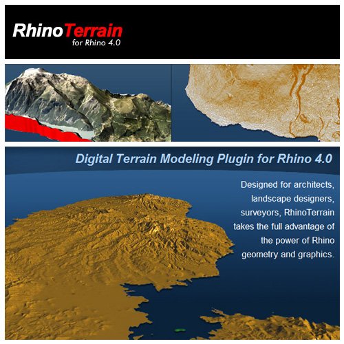

RhinoTerrain SARL 正式發布 RhinoTerrain for Rhinoceros 4.0,這個插件可以產生與分析精確的 3D 地形模型,可用於建築、土地調查、都市計劃工程、景觀規劃,並可由 3D 打印機輸出。功能摘要如下:
快速建立地形模型 - 可以從點、線、曲線建立地形模型,並提供 HardBreaklines 與 SoftBreakline 選項。RhinoTerrain 可以迅速處理數百萬個點的龐大地形數據。
真實的地形呈現 - 參考地理數據以正射影像 (OrthoPhoto) 對應產生真實的地形呈現與 3D 打印。
建立等高曲線 - 可以自動標注等高曲線高度,支持多核心運算技術處理大形的地形數據。
山地與高度梯度分析 - 以使用者定義的漸層顏色選項產生漂亮的影像。
載入地形文件 - 可以匯載入USGS DEM (Digital Elevation Model) 與 ArcView ShapeFile 文件。


The GeoModeling Experience
Enter the GeoModeling universe and discover
how RhinoTerrain associates Nurbs, point clouds
and meshes to deliver precise 3D data.
RhinoTerrain is a powerful tool to create, edit
and analyse digital terrain.
RhinoTerrain 1.8 adds to Rhinoceros :
Point cloud import and filtering
Geographic transformations
GoogleEarth, Geotiff, DEM,... imports
Profils and cross section creation
Powerful terrain analysis
And a lot more...
||||||||||||||||||||||||||||||||||||||||||||||||||||||||||||||||||||||||||||||||||||||||||||||||||||||||||||||||||||||||||||||||||||||||||||||||||||||||||||||||||||||||||||||||||||||||||||||||||
更多資訊請點擊訪問
||||||||||||||||||||||||||||||||||||||||||||||下載前必讀||||||||||||||||||||||||||||||||||||||||||||||
[安全檢測]
★未通過安全檢測
[安裝測試]
★未經過安裝測試,使用者後果自負與本論壇無關。
英文名: RhinoTerrain For Rhinoceros 4.0 SR8
資源格式: 壓縮包
版本: V1.8.2 Multilingual
發行時間: 2010年
制作發行: RhinoTerrain SARL
地區: 美國
語言: 英文,多語言
簡介:
RhinoTerrain SARL 正式發布 RhinoTerrain for Rhinoceros 4.0,這個插件可以產生與分析精確的 3D 地形模型,可用於建築、土地調查、都市計劃工程、景觀規劃,並可由 3D 打印機輸出。功能摘要如下:
快速建立地形模型 - 可以從點、線、曲線建立地形模型,並提供 HardBreaklines 與 SoftBreakline 選項。RhinoTerrain 可以迅速處理數百萬個點的龐大地形數據。
真實的地形呈現 - 參考地理數據以正射影像 (OrthoPhoto) 對應產生真實的地形呈現與 3D 打印。
建立等高曲線 - 可以自動標注等高曲線高度,支持多核心運算技術處理大形的地形數據。
山地與高度梯度分析 - 以使用者定義的漸層顏色選項產生漂亮的影像。
載入地形文件 - 可以匯載入USGS DEM (Digital Elevation Model) 與 ArcView ShapeFile 文件。
The GeoModeling Experience
Enter the GeoModeling universe and discover
how RhinoTerrain associates Nurbs, point clouds
and meshes to deliver precise 3D data.
RhinoTerrain is a powerful tool to create, edit
and analyse digital terrain.
RhinoTerrain 1.8 adds to Rhinoceros :
Point cloud import and filtering
Geographic transformations
GoogleEarth, Geotiff, DEM,... imports
Profils and cross section creation
Powerful terrain analysis
And a lot more...
||||||||||||||||||||||||||||||||||||||||||||||||||||||||||||||||||||||||||||||||||||||||||||||||||||||||||||||||||||||||||||||||||||||||||||||||||||||||||||||||||||||||||||||||||||||||||||||||||
更多資訊請點擊訪問
||||||||||||||||||||||||||||||||||||||||||||||下載前必讀||||||||||||||||||||||||||||||||||||||||||||||
[安全檢測]
★未通過安全檢測
[安裝測試]
★未經過安裝測試,使用者後果自負與本論壇無關。
相關資源:


- [應用軟件]在線帳薄 V0.969.0617.0
- [行業軟件]《Siemens SIMATIC WinCC flexible 2005 Edition 0406 最新3CD版》(Siemens SIMATIC WinCC Flexible 2005 Edition 0406)英文[Bin],行業軟件、資源下載
- [安全相關軟件]《頭像自動抽獎系統 v2012》(Avatar automatic lottery system)[我是好人]
- [系統工具]《Acronis系統備份還原工具》(Acronis® True Image Home 2010)v13.0 Build 5055 + Serial & BootCD[壓縮包]
- [應用軟件]《winfax10.3PRO傳真軟件附詳細操作說明》(Symantec.WinFax.PRO.v10.03)適用於XP以及之前版本[ISO],應用軟件、資源下載
- [應用軟件]3DMark03
- [應用軟件]《Mac虛擬平台軟件》(VMware Fusion v3.0.0.204229 MacOSX)[壓縮包]
- [軟件綜合]《威力導演12旗艦版》(CyberLink PowerDirector Ultimate)v12.0.2230.0[壓縮包]
- [軟件綜合]氣費管理系統2015旗艦版
- [行業軟件]《CAXA電子圖板機械版 2011》(CAXADraftMechanical2011)[壓縮包]
- [應用軟件]《Collins Cobuild詞典》(Collins Cobuild Advanced Learners English Dictionary)最新修訂第五版[Bin],應用軟件、資源下載
- [人文社科]《氣味》(Le pouvoir de Lodeur)(阿尼克·勒蓋萊)掃描版[PDF]
- [軟件綜合]《CG漫畫繪制軟件》(ComiLabo)更新1.0.20最新試用版[安裝包]
- [電腦基礎]《maya基礎教程》
- [操作系統]《經典windows主題70合一》,操作系統、資源下載
- [行業軟件]《Sage Abra HRMS 企業應用》(Sage Abra HRMS )v8.2[Bin]
- [人文社科]Vision Divine -《9 Degrees West Of The Moon》[MP3]
- [經濟管理]《當當創業內幕》掃描版[PDF]
- [人文社科]《紅潮風暴》(Crimson Tide)人人影視制作[HR-HDTV]
- [系統工具]《虛擬吉他和貝司放大器》(MAGIX Vandal Guitar Amp)v1.101[壓縮包]
- 《生物化學分析工具》(Geneious Pro)v4.8.5[壓縮包]
- 交通銀行網銀 2.2.0.0 官方版
- 《poedit漢化工具》(poedit for veket)1.46中文版[安裝包]
- 《多功能電腦輔助設計TurboCAD Pro V12》(IMSI TurboCAD Professional V12.0.38.3)2D/3D設計軟件,行業軟件、資源下載
- 《MapInfo 9 專業版》(MapInfo.Professional.v9.0.Build.42)
- 《高終流程規劃設計》(Corel iGrafx Enterprise v13.1.4.1175 Multilingua)[壓縮包]
- 《影視後期處理<動態遮罩制作>軟件》(SFX Silhouette)v4.5.4 x64[壓縮包]
- 淘寶助理 5.6.8.0 官方最新版
- 《Epi Data 3.0》(Epi Data 3.0)3.0(漢化為中國疾病預防控制中心版),行業軟件、資源下載
- 《Nemetschek Allplan v2006英文版》(Nemetschek Allplan v2006 0a3)多國語系但不含中文[Bin]
- 《3DSMax Design 2013 64位》(3DSMax Design 2013 Win 64bit)2013[安裝包]
- 《考勤計薪統計工具》(ZPAY Time Clock Window)v1.0.51.0+v1.0.52.0+v1.0.53.0+v1.0.15.0[壓縮包]
免責聲明:本網站內容收集於互聯網,本站不承擔任何由於內容的合法性及健康性所引起的爭議和法律責任。如果侵犯了你的權益,請通知我們,我們會及時刪除相關內容,謝謝合作! 聯系信箱:[email protected]
Copyright © 電驢下載基地 All Rights Reserved