《地圖繪制軟件》(Global Mapper v10.02)[壓縮包],行業軟件、資源下載 簡介: 簡介: 語言:英語 網址:http://www.rockware.com/product/overview.php?id=91 類別:地圖繪制軟件 Global Mapper 是一款地圖繪制軟件,不僅能夠將數據顯示為光柵地圖、高程地圖、矢量地圖,還可以對地圖作編輯、轉換、打印、記錄GPS及利用數據的GIS(地理信息系統)功能.6.xx版增加了直接訪問USGS(美國地質勘探局)衛星照片
"《地圖繪制軟件》(Global Mapper v10.02)[壓縮包],行業軟件、資源下載"介紹
簡介:
語言:英語
網址:http://www.rockware.com/product/overview.php?id=91
類別:地圖繪制軟件
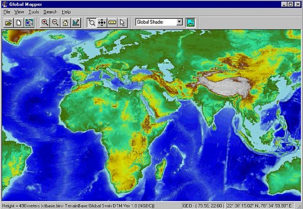
Global Mapper 是一款地圖繪制軟件,不僅能夠將數據顯示為光柵地圖、高程地圖、矢量地圖,還可以對地圖作編輯、轉換、打印、記錄GPS及利用數據的GIS(地理信息系統)功能.6.xx版增加了直接訪問USGS(美國地質勘探局)衛星照片TerraServer數據庫和Global Mapper內部的地形圖及以真實的3D方式查看高程地圖的功能.
浏覽、合成、輸入、輸出大部分流行的掃描點陣圖、等高線、矢量數據集的軟件,它可以編輯、轉換、打印各類地圖圖形文件,可以利用全球情報系統(GIS) 信息資源。它可以轉換數據集的投影方式以符合你的項目的座標系統,並可以同時對數據集的范圍進行裁剪。它還提供距離和面積計算,光柵混合、對比度調節、海拔高度查詢、視線計算,以及一些高級功能,如圖像校正、通過地表數據進行輪廓生成、通過地表數據觀察分水嶺、對3Dpoint數據轉換為三角多邊形和網格化等。通過內建的腳本語言或眾多的批處理轉換選項能夠高效地完成重復性任務。
引用Global Mapper
Global Mapper is more than just a viewer capable of displaying the most popular raster, elevation, and vector datasets. It converts, edits, prints, tracks GPS, and allows you to utilize GIS functionality on your datasets in one low cost and easy to use software package. Global Mapper also includes the ability to directly access the entire TerraServer database of USGS satellite imagery and topographic maps free of charge and to view elevation data in true 3D with any loaded raster imagery and vector data draped on top of it!
Your data files can be loaded as layers, for example a Digital Elevation Model (DEM) can be loaded with a scanned topographical map to create a 3D view of the map. A digital aerial image can be draped on the surface together with vector contour mapping to create a stunning and informative graphic. The results can be printed, or the workspace can be exported to a high resolution raster image for use in a presentation or report.
NFO:
代碼²
²²
²
²
²
²
²
²²
²²
²
² ²
°°°° ²² °°°°° ² °°°°° °°°°°
²²
² ²
²
sQz SAC ²
²
²
Global Mapper v10.02 c Global Mapper Software
² ִִִִִִִִִִִִִִִִִִִִִִִִִִִִִִִִִִִִִִִִִִִִִִִִִִִִִִִִִִִִִִִִִִִִִִִִִִִ ²
± Disks 6 x 5,00mb Date January 29, 2009 ±
° OS Windows °
² Release Description
~~~~~~~~~~~~~~~~~~~
Global Mapper is more than just a viewer capable of displaying the most
popular raster, elevation and vector datasets. It converts, edits,
prints, tracks GPS and allows you to utilize GIS functionality on your
datasets in one low-cost and easy-to-use software package.
Global Mapper also includes the ability to directly access multiple
online sources of imagery, topographic maps, and gridded terrain data.
This includes access to worldwide high resolution color imagery from
DigitalGlobe watermarked access for free and access to the entire
TerraServer-USA database of USGS satellite imagery and topographic maps
free-of-charge. Global Mapper also has the ability to easily access WMS
data sources, including built-in access to elevation data and color
imagery for the entire world, and to view elevation data in true 3D with
any loaded raster imagery and vector data draped on top of it!
°
Installation
²
± Just unpack install. Move patch.exe to installdir and use it.
°
Greetz
²
°
Contact Us
²
±
°
語言:英語
網址:http://www.rockware.com/product/overview.php?id=91
類別:地圖繪制軟件
Global Mapper 是一款地圖繪制軟件,不僅能夠將數據顯示為光柵地圖、高程地圖、矢量地圖,還可以對地圖作編輯、轉換、打印、記錄GPS及利用數據的GIS(地理信息系統)功能.6.xx版增加了直接訪問USGS(美國地質勘探局)衛星照片TerraServer數據庫和Global Mapper內部的地形圖及以真實的3D方式查看高程地圖的功能.
浏覽、合成、輸入、輸出大部分流行的掃描點陣圖、等高線、矢量數據集的軟件,它可以編輯、轉換、打印各類地圖圖形文件,可以利用全球情報系統(GIS) 信息資源。它可以轉換數據集的投影方式以符合你的項目的座標系統,並可以同時對數據集的范圍進行裁剪。它還提供距離和面積計算,光柵混合、對比度調節、海拔高度查詢、視線計算,以及一些高級功能,如圖像校正、通過地表數據進行輪廓生成、通過地表數據觀察分水嶺、對3Dpoint數據轉換為三角多邊形和網格化等。通過內建的腳本語言或眾多的批處理轉換選項能夠高效地完成重復性任務。
引用Global Mapper
Global Mapper is more than just a viewer capable of displaying the most popular raster, elevation, and vector datasets. It converts, edits, prints, tracks GPS, and allows you to utilize GIS functionality on your datasets in one low cost and easy to use software package. Global Mapper also includes the ability to directly access the entire TerraServer database of USGS satellite imagery and topographic maps free of charge and to view elevation data in true 3D with any loaded raster imagery and vector data draped on top of it!
Your data files can be loaded as layers, for example a Digital Elevation Model (DEM) can be loaded with a scanned topographical map to create a 3D view of the map. A digital aerial image can be draped on the surface together with vector contour mapping to create a stunning and informative graphic. The results can be printed, or the workspace can be exported to a high resolution raster image for use in a presentation or report.
NFO:
代碼²
²²
²
²
²
²
²
²²
²²
²
² ²
°°°° ²² °°°°° ² °°°°° °°°°°
²²
² ²
²
sQz SAC ²
²
²
Global Mapper v10.02 c Global Mapper Software
² ִִִִִִִִִִִִִִִִִִִִִִִִִִִִִִִִִִִִִִִִִִִִִִִִִִִִִִִִִִִִִִִִִִִִִִִִִִִ ²
± Disks 6 x 5,00mb Date January 29, 2009 ±
° OS Windows °
² Release Description
~~~~~~~~~~~~~~~~~~~
Global Mapper is more than just a viewer capable of displaying the most
popular raster, elevation and vector datasets. It converts, edits,
prints, tracks GPS and allows you to utilize GIS functionality on your
datasets in one low-cost and easy-to-use software package.
Global Mapper also includes the ability to directly access multiple
online sources of imagery, topographic maps, and gridded terrain data.
This includes access to worldwide high resolution color imagery from
DigitalGlobe watermarked access for free and access to the entire
TerraServer-USA database of USGS satellite imagery and topographic maps
free-of-charge. Global Mapper also has the ability to easily access WMS
data sources, including built-in access to elevation data and color
imagery for the entire world, and to view elevation data in true 3D with
any loaded raster imagery and vector data draped on top of it!
°
Installation
²
± Just unpack install. Move patch.exe to installdir and use it.
°
Greetz
²
°
Contact Us
²
±
°
- 上一頁:《有限元分析》(CAEFEM v9.3)[壓縮包],行業軟件、資源下載
- 下一頁:《標簽和條形碼設計制作工具》(TechnoRiverStudio Multi Edition v5.2.1623)[壓縮包],行業軟件、資源下載
相關資源:


- [網絡軟件]《吸血鬼起源》(Dracula Origin)硬盤版/動畫包資料下載
- [多媒體類]《刻錄軟件》(CDBurnerXP )v4.4.0.2905 PORTABLE[安裝包]
- [操作系統]《中國名山》(CMCHS10),操作系統、資源下載
- [行業軟件]《曲面設計》(AUTODESK ALIAS SURFACE)V2012[光盤鏡像]
- [行業軟件]《Photoshop柔化景深濾鏡》(OnOne Software FocalPoint v1.0.2 )[壓縮包],行業軟件、資源下載
- [行業軟件]《ACM 2012 X64 簡體中文版》(Autodesk_AutoCAD_Mechanical_2012_x64_SC)V2012 X64[壓縮包]
- [編程開發]《XML集成開發環境》(Stylus Studio 2006 Release 3 XML Enterprise Edition)
- [行業軟件]《數控編程》(MasterCAM X2 MR2 SP1)[ISO],行業軟件、資源下載
- [軟件綜合]名偵探柯南迷們看過來,專為你們做的軟件!(國語版全集)
- [多媒體類]《3GP格式轉換工具》(Bigasoft DVD to 3GP Converter) v1.7.15.4356 [壓縮包]
- [光盤游戲]《夢幻奇緣2》(FantasticFortune 2)繁體中文Clone版
- [光盤游戲]《王牌冒險第二章》(Top Trumps Adventures Vol. 2: Dogs & Dinosaurs)[Bin]
- [硬盤游戲]《武士的最終測驗》(Samurai Last Exam)v1.3.0.0硬盤版[壓縮包]
- [編程開發]《InstallShield 10.5 Premier版》(InstallShield 10.5 Premier Edition)PREMIER EDITION 10.5
- [其他圖書]《品茶酒咖啡必備:茶、紅葡萄酒、干邑、白葡萄酒、香槟、威士忌、啤酒、咖啡鑒賞手冊》掃描版 精裝彩印 附:煮咖啡DIY手冊[PDF]
- [網絡軟件]《孢子:銀河大冒險》(Spore Galactic Adventures)簡體中文1.05整合版[安裝包] 免費下載
- [編程開發]《Retas.HD 簡體中文版+送詳細教程》(Retas.HD)簡體中文版[光盤鏡像],行業軟件、資源下載
- [小說圖書]《真愛迷蹤》掃描版[PDF]
- [人文社科]《動物世界百科全書(上中下卷) 》高清全彩版[
- [人文社科]蔡琴 -《蔡琴。原聲帶》台版[APE]
- 《三維建模軟件》(Autodesk Mudbox v2012 SP1)多國語言版/Win32+Win64[壓縮包]
- 《Corel Painter 11簡體中文版》(Corel Painter)v.11[安裝包]
- 淘測測工具箱賣家版 1.9.1.5 綠色版
- 《專業財會軟件》(Clarysis Executive Powerpak)v5.0.0.2[壓縮包]
- 《Linux版本歐特克 Maya 2008》(Autodesk Maya 2008 for Linux)2008[安裝包]
- 《紋身工作室軟件》(Inkbook)v9.0.2.1096[壓縮包]
- 《三維數字樣機解決方案》(AUTODESK.INVENTOR.PRO)V2012 WIN32|WIN64[光盤鏡像]
- 《3D加工》(Delcam PowerMILL 6.008 +SP6)[Bin],行業軟件、資源下載
- 《嵌入式模塊ARM微控制器》(LabVIEW v8.5.1 Embedded Module for ARM Microcontrollers v1.1)[光盤鏡像],行業軟件、資源下載
- 《金蝶》(Kingdee)K3 v10.4 KIS v9.2[安裝包],行業軟件、資源下載
- 《浩辰CAD2009標准版專業版繁體版英文版》(GstarCAD 2009)2009版[安裝包]
- 《高頻電子設計》(AWR Design Environment v8.0.4)[壓縮包]
免責聲明:本網站內容收集於互聯網,本站不承擔任何由於內容的合法性及健康性所引起的爭議和法律責任。如果侵犯了你的權益,請通知我們,我們會及時刪除相關內容,謝謝合作! 聯系信箱:[email protected]
Copyright © 電驢下載基地 All Rights Reserved