《交互式GIS和影像處理》(IDRISI Andes V15.0)英文[光盤鏡像],行業軟件、資源下載 簡介: 簡介: 軟件名稱: IDRISI Andes V15.0 (交互式GIS和影像處理) 程序語言: 英文 軟件分類: 國外軟件 / 零售版 / 天文地理 文件大小: 488M 評價星級: 5 整理日期: 2006-5-13 11:15:49 頁面刷新: 2006-05-13 12:02:54 適用平台: 98/Me/NT/2000/XP/.Net/ [已通過安全檢測]SY
電驢資源下載/磁力鏈接資源下載:
- 下載位址: [www.ed2k.online][交互式GIS和影像處理].idrsan15.part1.rar
- 下載位址: [www.ed2k.online][交互式GIS和影像處理].idrsan15.part2.rar
全選
"《交互式GIS和影像處理》(IDRISI Andes V15.0)英文[光盤鏡像],行業軟件、資源下載"介紹
簡介:
軟件名稱: IDRISI Andes V15.0 (交互式GIS和影像處理)
程序語言: 英文
軟件分類: 國外軟件 / 零售版 / 天文地理
文件大小: 488M
評價星級: 5
整理日期: 2006-5-13 11:15:49
頁面刷新: 2006-05-13 12:02:54
適用平台: 98/Me/NT/2000/XP/.Net/
[已通過安全檢測]SYMANTEC.ANTIVIRUS.CORPORATE.V10.0.2.2000(英文精簡版本)
[已通過安裝測試]WinXP+SP2和WIN2003專業版 WIN98
軟件版權歸原作者及原軟件公司所有,如果你喜歡,請購買正版軟件
共享服務時間:每天:8點至24:30點
共享服務器:DonkeyServer No3 . DonkeyServer No9
DRISI Andes是一個交互式GIS和影像處理解決方案,提供了200個模塊來分析和處理數字空間信息。IDRISI提供了業界最廣泛的GIS和影像處理工具。這些工具包括土地規劃、決策支持、風險分析等等。包括:對空間數據統計,地表分析,空間建模的分析。
IDRISI Andes V15.0 於2006年4月釋放,這是自1987年以來,第15次發行的有關IDRISI Andes版本。IDRISI目前已在超過175個國家被廣大研究員和專業人士使用。
With IDRISI Andes, you can:
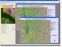
Explore, predict, and model impacts on land cover change with the innovative Land Change Modeler facility.
The Land Change Modeler for Ecological Sustainability is organized around a set of tasks for land cover change assessment, change prediction, assessment of its impacts on habitat and biodiversity, and the exploration of planning interventions.
Process remotely-sensed imagery with a full suite of image processing techniques including innovative
soft classifiers and neural network and decision tree analyses.
IDRISI has incomparable classification tools. Machine learning classifiers consist of three neural network classifiers--multi-layer perceptron, self organizing map, and fuzzy art map.
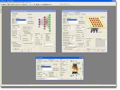
Utilize cutting-edge decision support and uncertainty management tools to allocate resources and create suitability maps.
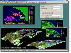
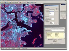
This screenshot illustrates some of the data products developed for a study on the effects of sea level rise on a coastal rice-producing area in Vietnam. Part of the study included prediction of future sea level and inundated areas. This portion of the study explicitly incorporated uncertainty in the elevation data as well as the projected sea level rise. The probability of inundation image (upper left) was then thresholded based upon an acceptable level of risk. The multi-criteria analysis was a prediction model of where people might relocate after inundation, thus a predicted landcover image was produced
Compare pairs of images or analyze trends and anomalies from long time series imagery.
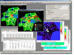
IDRISI provides the most extensive set of change and time series analysis tools in the industry. This screenshot illustrates Markov Chain Analysis, a technique for predictive change modeling. Predictions of future change are based on changes that have occurred in the past.
Import/export with a wide variety of data sources, including all major vector and imagery formats.
IDRISI supports the import of HDF-EOS 4 format which is useful for importing ASTER and MODIS data.
And even more…
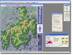
IDRISI provides full map composition capabilities, including multiple raster and vector layers, layer blending, interactive RGB compositing, multiple legends, title, text labels, grid, north arrow, scale bar, text and image insets. This image depicts the White Mountain region in New Hampshire, USA, including data for elevation, roads, and boundaries using various layer blending options
軟件名稱: IDRISI Andes V15.0 (交互式GIS和影像處理)
程序語言: 英文
軟件分類: 國外軟件 / 零售版 / 天文地理
文件大小: 488M
評價星級: 5
整理日期: 2006-5-13 11:15:49
頁面刷新: 2006-05-13 12:02:54
適用平台: 98/Me/NT/2000/XP/.Net/
[已通過安全檢測]SYMANTEC.ANTIVIRUS.CORPORATE.V10.0.2.2000(英文精簡版本)
[已通過安裝測試]WinXP+SP2和WIN2003專業版 WIN98
軟件版權歸原作者及原軟件公司所有,如果你喜歡,請購買正版軟件
共享服務時間:每天:8點至24:30點
共享服務器:DonkeyServer No3 . DonkeyServer No9
DRISI Andes是一個交互式GIS和影像處理解決方案,提供了200個模塊來分析和處理數字空間信息。IDRISI提供了業界最廣泛的GIS和影像處理工具。這些工具包括土地規劃、決策支持、風險分析等等。包括:對空間數據統計,地表分析,空間建模的分析。
IDRISI Andes V15.0 於2006年4月釋放,這是自1987年以來,第15次發行的有關IDRISI Andes版本。IDRISI目前已在超過175個國家被廣大研究員和專業人士使用。
With IDRISI Andes, you can:
Explore, predict, and model impacts on land cover change with the innovative Land Change Modeler facility.
The Land Change Modeler for Ecological Sustainability is organized around a set of tasks for land cover change assessment, change prediction, assessment of its impacts on habitat and biodiversity, and the exploration of planning interventions.
Process remotely-sensed imagery with a full suite of image processing techniques including innovative
soft classifiers and neural network and decision tree analyses.
IDRISI has incomparable classification tools. Machine learning classifiers consist of three neural network classifiers--multi-layer perceptron, self organizing map, and fuzzy art map.
Utilize cutting-edge decision support and uncertainty management tools to allocate resources and create suitability maps.
This screenshot illustrates some of the data products developed for a study on the effects of sea level rise on a coastal rice-producing area in Vietnam. Part of the study included prediction of future sea level and inundated areas. This portion of the study explicitly incorporated uncertainty in the elevation data as well as the projected sea level rise. The probability of inundation image (upper left) was then thresholded based upon an acceptable level of risk. The multi-criteria analysis was a prediction model of where people might relocate after inundation, thus a predicted landcover image was produced
Compare pairs of images or analyze trends and anomalies from long time series imagery.
IDRISI provides the most extensive set of change and time series analysis tools in the industry. This screenshot illustrates Markov Chain Analysis, a technique for predictive change modeling. Predictions of future change are based on changes that have occurred in the past.
Import/export with a wide variety of data sources, including all major vector and imagery formats.
IDRISI supports the import of HDF-EOS 4 format which is useful for importing ASTER and MODIS data.
And even more…
IDRISI provides full map composition capabilities, including multiple raster and vector layers, layer blending, interactive RGB compositing, multiple legends, title, text labels, grid, north arrow, scale bar, text and image insets. This image depicts the White Mountain region in New Hampshire, USA, including data for elevation, roads, and boundaries using various layer blending options
- 上一頁:《土地測量》(Autodesk Survey)V2007[Bin],行業軟件、資源下載
- 下一頁:《IMSI Design CAD 3DMax 16.2 2D設計》(IMSI Design CAD 3DMax 16.2)英文[ISO],行業軟件、資源下載
相關資源:


- [行業軟件]《結構有限元分析》(Csi Sap2000 V11.0 MAGNiTUDE)[Bin],行業軟件、資源下載
- [編程開發]《缺陷跟蹤及管理軟件》(Atlassian JIRA)v4.2.4[壓縮包]
- [多媒體類]《品尼高視頻編輯軟件》(Pinnacle Studio HD Ultimate Collection)v15[光盤鏡像]
- [應用軟件]《Roxio多媒體編輯軟件套裝》(Roxio Easy Media Creator Suite v9.0 MULTI5)[Bin]
- [應用軟件]《譯典通》(Dr.eye)7.0專業版
- [多媒體類]《CD&DVD - Maker 7 Titanium Suite》(CD&DVD - Maker 7 Titanium Suite)零售光盤版[ISO]
- [多媒體類]《Zero-G Nostalgia (專業虛擬樂器、音色采樣)》(Zero-G Nostalgia)1[ISO]
- [軟件綜合]欣欣供電收費軟件階梯電費管理系統2016旗艦版
- [網絡軟件]《Orbit下載器》(Orbit Downloader )多國語言版含中文[安裝包]
- [安全相關軟件]《MCAFEE 殺毒軟件》(MCAFEE.VIRUSSCAN)2005.V9.0[Bin]
- [人文社科]《日本人》([美]埃德溫.賴肖爾)缺封面掃描版[PDF]
- [生活圖書]《要愛就愛這樣的男人》掃描版[PDF]
- [多媒體類]《DVD音頻提取工具》(ImTOO DVD Audio Ripper)v6.6.0.0623.Multilanguage[壓縮包]
- [教育綜合]《唐應山美術基礎講堂——素描》[RMVB]
- [小說圖書]《第八日的蟬》文字版[PDF]
- [其他圖書]《圖解泰拳實戰技法》(曹建泉 & 周共培)掃描版[PDF]
- [教育綜合]詳解MATLAB/Simulink通信系統建模與仿真 視頻教程
- [多媒體類]《模擬合成器》(Arturia Jupiter8 V)[壓縮包]
- [軟件綜合]《Mandrake Linux10.0-Official》(Mandrake Linux10.0-Official)[ISO]
- [行業軟件]《安捷倫射頻EDA軟件》(Agilent Genesys v2008 01)[Bin]
- 《俞斌-圍棋級位測試6000題》[ISO]
- 《SDRC I-DEAS NX12M2》[ISO]
- 《引物設計軟件》(Molecular Biology Insights Oligo)v7.53[壓縮包]
- (6)photoshop教程_photoshop工具性質總結_51RGB
- 《老牌數控編程軟件 新版》(MasterCAM X (10.0))x 10
- 《Adobe CS5 蘋果電腦 官方獨立安裝包 PS AI ID (簡、繁、韓語言)》(Adobe CS5 for Mac 官方獨立安裝包 PS AI ID (簡、繁、韓語言))CS5 [光盤鏡像]
- 《SimufactForming金屬鋼材集成仿真環境》(Simufact Forming v8.1 SP1 Windows32)[光盤鏡像],行業軟件、資源下載
- 《結構通用有限元計算軟件》(SAP2000 V15.2.0)(新增V15.2.1)[壓縮包]
- 全是綠色軟件總有你需要的
- 《終極化學生物設計軟件》(ChemBioOffice WorkGroup Ultra 2009 v11.0.2)[光盤鏡像]
- 《數學運算軟件》(Texas Instruments Nspire CAS Software v1.6 Teacher Edition)[壓縮包]
- 《AKTA重做系統》(AKTA Unicorn 5.11)5.11[壓縮包],行業軟件、資源下載
免責聲明:本網站內容收集於互聯網,本站不承擔任何由於內容的合法性及健康性所引起的爭議和法律責任。如果侵犯了你的權益,請通知我們,我們會及時刪除相關內容,謝謝合作! 聯系信箱:[email protected]
Copyright © 電驢下載基地 All Rights Reserved