《加拿大等高線地圖 2009版》(Garmin Topo Canada 2009)[壓縮包],行業軟件、資源下載 簡介: 中文名: 加拿大等高線地圖 2009版英文名: Garmin Topo Canada 2009別名: Garmin Topo Canada ver. 4資源格式: 壓縮包發行時間: 2009年制作發行: Garmin地區: 美國語言: 英文簡介: 軟件類型:行業軟件 交通運輸 軟件性質:免費軟件 操作系統:windows/mac 網站鏈接:http://www.garmin.com/
電驢資源下載/磁力鏈接資源下載:
- 下載位址: [www.ed2k.online][加拿大等高線地圖.2009版].TopoCanada_v4.7z.001
- 下載位址: [www.ed2k.online][加拿大等高線地圖.2009版].TopoCanada_v4.7z.002
- 下載位址: [www.ed2k.online][加拿大等高線地圖.2009版].TopoCanada_v4.7z.003
- 下載位址: [www.ed2k.online][加拿大等高線地圖.2009版].TopoCanada_v4.7z.004
- 下載位址: [www.ed2k.online][加拿大等高線地圖.2009版].TopoCanada_v4.7z.005
- 下載位址: [www.ed2k.online][加拿大等高線地圖.2009版].TopoCanada_v4.7z.006
- 下載位址: [www.ed2k.online][加拿大等高線地圖.2009版].TopoCanada_v4.7z.007
- 下載位址: [www.ed2k.online][加拿大等高線地圖.2009版].TopoCanada_v4.7z.008
- 下載位址: [www.ed2k.online][加拿大等高線地圖.2009版].TopoCanada_v4.7z.009
- 下載位址: [www.ed2k.online][加拿大等高線地圖.2009版].TopoCanada_v4.7z.010
- 下載位址: [www.ed2k.online][加拿大等高線地圖.2009版].TopoCanada_v4.7z.011
全選
"《加拿大等高線地圖 2009版》(Garmin Topo Canada 2009)[壓縮包],行業軟件、資源下載"介紹
中文名: 加拿大等高線地圖 2009版英文名: Garmin Topo Canada 2009別名: Garmin Topo Canada ver. 4資源格式: 壓縮包發行時間: 2009年制作發行: Garmin地區: 美國語言: 英文簡介:
軟件類型:行業軟件 交通運輸
軟件性質:免費軟件
操作系統:windows/mac
網站鏈接:http://www.garmin.com/
病毒檢測:經本機由Norton 360檢測未發現病毒 (特征庫更新時間:2010/01/28)
這是2009年發布的加拿大地區等高線地圖。
1:50000的NTS數據使得在BaseCamp和Garmin某些型號的GPS接收器中以3D方式浏覽地圖成為可能。
隨盤附帶BaseCamp軟件 (可以理解成是支持3D地圖的MapSource)
注意:壓縮包比較大,謹慎下載。解壓大概需要5.3G硬盤空間。所以想放在一張dvd裡有些困難。。
再注意:Garmin的部分老機型和導航用機型不支持這個地圖,詳情請見Garmin官網。
再再注意:如果解壓縮時出現問題,請到這裡下載最新版本的7zip進行解壓。
再再再注意:在mac上使用的用戶,請直接雙擊解壓包中的.gmap文件進行安裝。
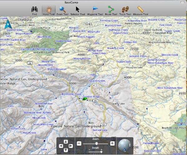
地圖看起來大概是這個樣子:
本人長期供源,細水長流。。
官網上摘下來的簡介:
Overview:
TOPO Canada covers the finer details of the outdoors, including terrain contours, topo elevations, summits, routable roads and trails, rivers, lakes and geographical points. TOPO maps are ideal for hiking, hunting, camping, cycling and communing with nature. Coverage includes topographic detail throughout Canada. Available on DVD.
Features:
- Digital topographic maps for Canada.
- Provides detailed maps based on digital 1:250,000 and 1:50,000 scale NTS data.
- Terrain contour and elevation information, along with summits, peaks and geographic.
points.
- Allows you to search by city, point, river or lake.
- Contains many routable roads, trails, interstates and highways.
- Includes points of interest such as parks, campgrounds, scenic lookouts, picnic sites and more.
- Coastlines, shorelines, wetlands, perennial and seasonal streams.
- National, state, local parks, forests and wilderness areas.
- Includes BaseCamp™ software which allows you to view and manage waypoints, routes and tracks between your computer and your Garmin device.
軟件類型:行業軟件 交通運輸
軟件性質:免費軟件
操作系統:windows/mac
網站鏈接:http://www.garmin.com/
病毒檢測:經本機由Norton 360檢測未發現病毒 (特征庫更新時間:2010/01/28)
這是2009年發布的加拿大地區等高線地圖。
1:50000的NTS數據使得在BaseCamp和Garmin某些型號的GPS接收器中以3D方式浏覽地圖成為可能。
隨盤附帶BaseCamp軟件 (可以理解成是支持3D地圖的MapSource)
注意:壓縮包比較大,謹慎下載。解壓大概需要5.3G硬盤空間。所以想放在一張dvd裡有些困難。。
再注意:Garmin的部分老機型和導航用機型不支持這個地圖,詳情請見Garmin官網。
再再注意:如果解壓縮時出現問題,請到這裡下載最新版本的7zip進行解壓。
再再再注意:在mac上使用的用戶,請直接雙擊解壓包中的.gmap文件進行安裝。
地圖看起來大概是這個樣子:
本人長期供源,細水長流。。
官網上摘下來的簡介:
Overview:
TOPO Canada covers the finer details of the outdoors, including terrain contours, topo elevations, summits, routable roads and trails, rivers, lakes and geographical points. TOPO maps are ideal for hiking, hunting, camping, cycling and communing with nature. Coverage includes topographic detail throughout Canada. Available on DVD.
Features:
- Digital topographic maps for Canada.
- Provides detailed maps based on digital 1:250,000 and 1:50,000 scale NTS data.
- Terrain contour and elevation information, along with summits, peaks and geographic.
points.
- Allows you to search by city, point, river or lake.
- Contains many routable roads, trails, interstates and highways.
- Includes points of interest such as parks, campgrounds, scenic lookouts, picnic sites and more.
- Coastlines, shorelines, wetlands, perennial and seasonal streams.
- National, state, local parks, forests and wilderness areas.
- Includes BaseCamp™ software which allows you to view and manage waypoints, routes and tracks between your computer and your Garmin device.
相關資源:


- [應用軟件]《無紙化辦公系統
- [行業軟件]《飛機翼型設計軟件》(Profili)v2.30a[壓縮包]
- [行業軟件]《E8支票(票據)打印軟件》9.25[壓縮包]
- [多媒體類]《管風琴合成器》(Native.Instruments.B4.II.v2.0)
- [行業軟件]從菜鳥一步一步教你制作手機APP (DZ棒棒團)
- [應用軟件]《搜狗拼音》[安裝包],應用軟件、資源下載
- [編程開發]《ps3游戲軟件開發工具》(PlayStation 3 Software Development Kit)【UP Phyre_Engine】[壓縮包]
- [多媒體類]《集成多媒體播放器》(Cowon JetAudio)更新v8.0.16.2000.Plus.VX[壓縮包]
- [行業軟件]《中學教育的動態數學軟件》(GeoGebra for veket)4.2.31 中文版(附中文教程+附視頻教程)[安裝包]
- [應用軟件]《虛擬打印機程序》(FinePrint)v6.13/含注冊表+破解文件[壓縮包]
- [英語學習資料]Cher Lloyd -《Sorry Im Late》[iTunes Plus AAC] 音樂下載
- [行業軟件]《金蝶K3精益版 V12.0.0》(Kingdee K3 LEAN)演示版[光盤鏡像],行業軟件、資源下載
- [英語學習資料]《滬江日語原創:視聽每日一句之日樂篇》更新到2011年11月[壓縮包]
- [其他圖書]《當代藥用植物典(第一冊)》掃描版[PDF]
- [其他資源綜合]《郭德綱長篇單口相聲集》[MP3] 資料下載
- [人文社科]《堪薩斯的兇屋》(Sightings: Heartland Ghost)[DVDRip]
- [藝術體育]《中國功夫跤》
- [生活圖書]《玩商:玩具博士教你如何巧妙地玩耍》掃描版[PDF]
- [人文社科]Celine Dion -《Unison》[APE]
- [編程開發]《編程控件》(Codejock.Xtreme.Suite.Pro.ActiveX)v13.2.1.Retail.Incl.Keymaker-ZWT[壓縮包]
- 《ComponentArt》(ComponentArt)2007_1_1556,包含源代碼[ISO],編程開發、資源下載
- 《專業UML建模Borland Together Architect 2006》,編程開發、資源下載
- 《虛幻3 游戲引擎軟件開發包2010年11月版》(Unreal Development Kit 2010-11)2010年11月版[安裝包]
- 《JAVA開發合集》,編程開發、資源下載
- 《Visual Basic 6.0.with.SP6 大企龍卷風集成安裝版》(Visual Basic 6.0.with.SP6)6。0,編程開發、資源下載
- 《代碼編輯器》(SlickEdit 2011)v16.0.0.6[壓縮包]
- 《Microsoft Document Explorer 2008及簡體中文語言包》(Microsoft Document Explorer 2008及簡體中文語言包)2008[安裝包],編程開發、資源下載
- 《Visual Studio插件》(Whole Tomato Visual Assist X)更新v10.6.1850.0修正版/含破解補丁[壓縮包]
- 《CodeSmith 代碼生成工具專業版》(CodeSmith )v4.1.2 Pro,編程開發、資源下載
- 《CAD/CAM/CAE集成軟件》(PTC Pro/ENGINEER Wildfire v5.0 M010 Win32/64)[光盤鏡像],行業軟件、資源下載
- 《Pro ENGINEER v5 m030》(Pro ENGINEER v5 m030)含破解[壓縮包],行業軟件、資源下載
- 《安裝程序制作軟件》(InstallShield 2008 v14 Premier Edition & Professional Edition)
免責聲明:本網站內容收集於互聯網,本站不承擔任何由於內容的合法性及健康性所引起的爭議和法律責任。如果侵犯了你的權益,請通知我們,我們會及時刪除相關內容,謝謝合作! 聯系信箱:[email protected]
Copyright © 電驢下載基地 All Rights Reserved